


)
)
IN CANADA
GUARANTEE
IN ONTARIO
CAD$ 388.00
Omnia Product Expert is nline !
FOUND A LOWER PRICE? We'll Beat Any Lower Price You Find!
Some Condition Applies*
Garmin Bluechart 174 Marine Cartography 010-C0924-00 SKU Listing / Specs
| Purchase | Part Number | Image View | Name | Detail Specs | UPC |
|---|---|---|---|---|---|
|
SKU: 010-C0924-00
CAD$ 388
|
 Enlarged View |
Garmin Bluechart 174 Marine Cartography 010-C0924-00 SPECIAL ORDER
SPECIAL ORDER (Estimated Ship Date: 4 - 8 Weeks) UpdatedOn: 2/21/2026 12:00:00 AM |
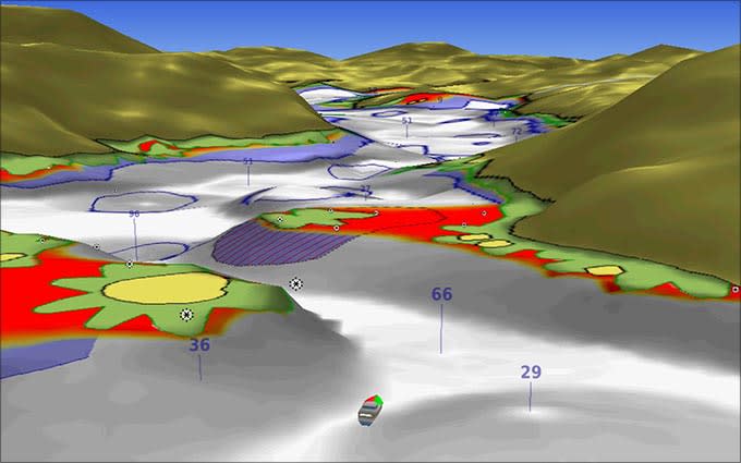
Universal Fit Product. BlueChart® g2 Vision® HD - VAW005R - The Gulf & Red Sea - microSD™/SD™ Coverage: The Arabian Peninsula beginning at the Mediterranean Sea from Beirut to Alexandria. Coverage includes the Suez Canal, Gulf of Aqaba, and the Red Sea and Gulf of Aden in their entirety. Includes the Strait of Hormuz, Gulf of Oman, and coast of Somalia in the south. Coverage of Kuwait, Saudi Arabia, Qatar, United Arab Emirates, along the southern coast of the Gulf and Iran along the northern coast. Coverage of Yemen and Oman coasts along the Indian Ocean to the Gulf of Oman, including Pakistan along the north coast, with general coverage of the Arabian Sea frmo Qamar Bay to the Delta of the Indus River. Included in this overall general coverage are numerous detailed charts covering areas such as Alexandria, Egy., Beirut, Leb., Al-Fuhaihil, Ad- Dammam, Bahrain, Ad-Dauha, and Abu Dhabi, Jiddah, Sau., Djibouti, Dji., and Aden, Yem. Our Premium Chart Offering Derived from official charts and private sources to provide navigational aids, spot soundings, depth contours, tides and currents, and detailed harbors and marinasGarmin Auto Guidance technology shows a suggested route to a destination¹ Depth Range Shading for up to 10 depth ranges enables you to view your target depth at a glance Up to 1-foot contours provide a more accurate depiction of the bottom structure for improved fishing charts and navigation Shallow Water Shading feature allows for depth shading at a user-defined level to aid in navigation Unique 3D views like MarinerEye and FishEye provide additional perspective both above and below the water line High-resolution satellite imagery of ports, marinas, bridges and navigational landmarks for superior situational awareness Auto Guidance¹ Auto Guidance technology quickly calculates a suggested route using your boat's dimensions and a suggested path to follow. Depth Range Shading Displays high-resolution Depth Range Shading for up to 10 depth ranges so you can view your designated target depth. Detailed Contours BlueChart g2 Vision HD features 1-foot contours that provide a more accurate depiction of bottom structure for improved fishing charts and enhanced detail in swamps, canals and port plans. MarinerEye View Provides a 3-D representation of the ocean floor as seen from below the waterline. FishEye View Provides a 3-D representation of the surrounding area both above and below the waterline. Aerial Photography Crystal clear aerial photography shows exceptional detail of many ports, harbors and marinas and is ideal when entering unfamiliar ports. ¹Auto Guidance is for planning purposes only and does not replace safe navigation practices WARNING: This product can expose you to chemicals which are known to the State of California to cause cancer, birth defects or other reproductive harm. For more information go to P65Warnings.ca.gov. This product may not be returned to the original point of purchase. Please contact the manufacturer directly with any issues or concerns. |
753759078249 |
Hot Product recommendation:


BlueChart® g2 Vision® HD - VAW005R - The Gulf & Red Sea - microSD™/SD™
Coverage:
The Arabian Peninsula beginning at the Mediterranean Sea from Beirut to Alexandria. Coverage includes the Suez Canal, Gulf of Aqaba, and the Red Sea and Gulf of Aden in their entirety. Includes the Strait of Hormuz, Gulf of Oman, and coast of Somalia in the south. Coverage of Kuwait, Saudi Arabia, Qatar, United Arab Emirates, along the southern coast of the Gulf and Iran along the northern coast. Coverage of Yemen and Oman coasts along the Indian Ocean to the Gulf of Oman, including Pakistan along the north coast, with general coverage of the Arabian Sea frmo Qamar Bay to the Delta of the Indus River. Included in this overall general coverage are numerous detailed charts covering areas such as Alexandria, Egy., Beirut, Leb., Al-Fuhaihil, Ad- Dammam, Bahrain, Ad-Dauha, and Abu Dhabi, Jiddah, Sau., Djibouti, Dji., and Aden, Yem.
Our Premium Chart Offering
- Derived from official charts and private sources to provide navigational aids, spot soundings, depth contours, tides and currents, and detailed harbors and marinas
- Garmin Auto Guidance technology shows a suggested route to a destination¹
- Depth Range Shading for up to 10 depth ranges enables you to view your target depth at a glance
- Up to 1-foot contours provide a more accurate depiction of the bottom structure for improved fishing charts and navigation
- Shallow Water Shading feature allows for depth shading at a user-defined level to aid in navigation
- Unique 3D views like MarinerEye and FishEye provide additional perspective both above and below the water line
- High-resolution satellite imagery of ports, marinas, bridges and navigational landmarks for superior situational awareness
Auto Guidance¹
Auto Guidance technology quickly calculates a suggested route using your boat's dimensions and a suggested path to follow.
Depth Range Shading
Displays high-resolution Depth Range Shading for up to 10 depth ranges so you can view your designated target depth.
Detailed Contours
BlueChart g2 Vision HD features 1-foot contours that provide a more accurate depiction of bottom structure for improved fishing charts and enhanced detail in swamps, canals and port plans.
MarinerEye View
Provides a 3-D representation of the ocean floor as seen from below the waterline.
FishEye View
Provides a 3-D representation of the surrounding area both above and below the waterline.
Aerial Photography
Crystal clear aerial photography shows exceptional detail of many ports, harbors and marinas and is ideal when entering unfamiliar ports.
¹Auto Guidance is for planning purposes only and does not replace safe navigation practices
WARNING: This product can expose you to chemicals which are known to the State of California to cause cancer, birth defects or other reproductive harm. For more information go to P65Warnings.ca.gov.
This product may not be returned to the original point of purchase. Please contact the manufacturer directly with any issues or concerns.